Myanmar
Asia Zawgyi Travel, DMCTHE REPUBLIC OF THE UNION OF MYANMAR
ပြည်ထောင်စုသမ္မတ မြန်မာနိုင်ငံတော်
MYANMAR, formerly known as BURMA, is the largest country in South East Asia. Population of just over fifty-three million is a culturally rich mix of more than a hundred ethnic groups and dialects. Strategically situated between the world’s two most populous nations, China and India. Myanmar has a distinctive ancient culture, sharing traditions with both neighbors.
In the 19th century, Burmese rulers sought to maintain their traditional influence in the western areas of Assam, Manipur and Arakan. Pressing them, however, was the British East India Company, which was expanding its interests eastwards over the same territory. Over the next sixty years, diplomacy, raids, treaties and compromises, known collectively as the Anglo-Burmese Wars, continued until Britain proclaimed control over most of Burma. With the fall of Mandalay, all of Burma came under British rule, being annexed on 1 January 1886.
On 1 April 1937, Burma became a separately administered colony of Britain, and Ba Maw became the first Prime Minister and Premier of Burma. Ba Maw was an outspoken advocate for Burmese self-rule, and he opposed the participation of Britain, and by extension Burma, in World War II. He resigned from the Legislative Assembly and was arrested for sedition. In 1940, before Japan formally entered the war, Aung San formed the Burma Independence Army in Japan.
As a major battleground, Burma was devastated during World War II by the Japanese invasion. Within months after they entered the war, Japanese troops had advanced on Rangoon, and the British administration had collapsed. A Burmese Executive Administration headed by Ba Maw was established by the Japanese in August 1942. Wingate‘s British Chindits were formed into long-range penetration groups trained to operate deep behind Japanese lines. A similar American unit, Merrill’s Marauders, followed the Chindits into the Burmese jungle in 1943.
Beginning in late 1944, allied troops launched a series of offensives that led to the end of Japanese rule in July 1945. Although many Burmese fought initially for the Japanese as part of the Burma Independence Army, many Burmese, mostly from the ethnic minorities, served in the British Burma Army. The Burma National Army and the Arakan National Army fought with the Japanese from 1942 to 1944 but switched allegiance to the Allied side in 1945.
Following World War II, Aung San negotiated the Panglong Agreement with ethnic leaders that guaranteed the independence of Myanmar as a unified state. Aung Zan Wai, Pe Khin, Bo Hmu Aung, Sir Maung Gyi, Sein Mya Maung, Myoma U Than Kywe were among the negotiators of the historic Panglong Conference negotiated with Bamar leader General Aung San and other ethnic leaders in 1947. In 1947, Aung San became Deputy Chairman of the Executive Council of Myanmar, a transitional government. But in July 1947, political rivals assassinated Aung San and several cabinet members.
On 4 January 1948, the nation became an independent republic, under the terms of the Burma Independence Act 1947. The new country was named the Union of Burma, with Sao Shwe Thaik as its first president and U Nu as its first prime minister. Unlike most other former British colonies and overseas territories, Burma did not become a member of the Commonwealth. A bicameral parliament was formed, consisting of a Chamber of Deputies and a Chamber of Nationalities, and multi-party elections were held in 1951–1952, 1956 and 1960.
On 2 March 1962, the military led by General Ne Win took control of Burma through a coup d’état, and the government had been under direct or indirect control by the military since then. Between 1962 and 1974, Myanmar was ruled by a revolutionary council headed by the general. Almost all aspects of society (business, media, production) were nationalised or brought under government control under the Burmese Way to Socialism. A new constitution of the Socialist Republic of the Union of Burma was adopted in 1974. Until 1988, the country was ruled as a one-party system, with the general and other military officers resigning and ruling through the Burma Socialist Programme Party (BSPP). During this period, Myanmar became one of the world’s most impoverished countries.
Burma was known as “the rice bowl of Asia” in the late 1950s, and was the leading economic state of the region when its fledgling democratic government was deposed by a xenophobic military dictator. In August 1988, become well known uprising which is 8-8-88 was a political turning point. Even so, people suffered for another quarter of a century under different military rulers before Myanmar finally emerge from dark days, electing a new, mainly democratic, parliament in 2012, although seats are still reserve for military representatives.
A quasi-civilian government was formed, and today further democratic reforms are underway as Myanmar approaches fresh elections. Its most famous political detainee, Aung San Suu Kyi, the Nobel Peace Laureate, who was released after nearly twenty years of under house arrest in 2010, and appointed as a State Counsellor of the Republic of the Union of Myanmar after 2015 general election. Again, The allegedly governing National League for Democracy (NLD), the party of State Counsellor Aung San Suu Kyi, contested against a number of minor parties in Myanmar’s 2020 parliamentary election. However, on the morning of February 1, 2021, some NLD party officials were seized by the military on suspicion of election fraud and corruption. The Military Chief Senior General Min Aung Hlaing appointed a caretaker administration, and the government and State Administrative Council announced that a free and fair election would be held in August 2022.
The most fascinating aspect of Myanmar history is its chronology, which includes many national flags and political systems from before and after independence. In summary, there are eight major periods, which are as follows:

Myanmar people are by nature friendly and polite, and are traditionally easygoing. The majority of the population are devout Buddhists, and there are pagodas and meditation centers all over the country. And others Christians, Islamic, Hindus, and others religions are freely devout as well.
While your host will be naturally polite and accommodating, you may have to go through a steep learning curve to understand the dos and don’ts of Myanmar’s social customs. Culture Smart! Myanmar provides vital insights into the inner life of the people, their history, traditions, attitudes, and work ethic, and gives practical advice on what to expect and how to behave in different circumstances. It offers you a starting point to discover for yourself the charms of this beautiful, resource-rich, and intriguing country.
KEY FACTS
| OFFICIAL NAME | The Republic of the Union of Myanmar | Pyidaunzu Thanmada Myanmar Nainngandaw |
| GOVERNMENT | Unitary parliamentary constitutional republic |
Upper house – House of Nationalities Lower house – House of Representatives |
| PRESIDENT | H.E U Myint Swe (Acting) | |
| VICE PRESIDENT | H.E Henry Van Thio | |
| CAPITAL CITY | Naypyidaw (Since 2005) | Administrative |
| BUSINESS CENTER | Yangon | Largest city and former capital |
| OFFICIAL LANGUAGE | Burmese | Also official script |
| AREA | 676,578 km2 (261,228 sq mi) | 3.06% of water |
| POPULATION | 56.2 million (2023) | 76/km2 (196.8/sq mi) density |
| CLIMATE | Tropical monsoon | |
| ETHNIC MAKEUP | Bamar 68%, Shan 9%, Karen 7%, Rakhine 4%, Mon 2%, Others 10% | |
| RELIGION | Theravada Buddhism 87.9%, Christianity 6.2%, Islam 4.3%, Others 1.6% | |
| CURRENCY |
Kyat (K) (MMK) (US $1.00 is roughly equivalent to 3,320 kyats) |
Kyat denominations: 1, 5, 10, 20, 50, 100, 200, 500, 1000, 5000, 10000, 20000 paper money |
| TIME ZONE | GMT+6:30 | |
| DRIVING SIDE | Right | |
| CALLING CODE | +95 | |
| CALENDAR | Myanmar uses two calendars: Gregorian and Buddhist | The lunar Buddhist calendar is 638 years behind Gregorian Calendar. |
|
ECONOMY |
Market economy is nascent stage | Business hours: 9:00-17:00, Monday to Friday ( half day for Saturday in some private office) |
| ADULT LITERACY | 89.5% | |
| ELECTRICITY | 220 Volts, 50 Hz | Range of plug types used. Adaptors needed for US appliances. |
| INTERNET TLD | .mm | |
| BAGAN DYNASTY | 23 December 894 | The first Kingdom was founded as a collision of Pyu city states (Hanlin, Beikthano, & Sriksetra which are UNESCO World Heritage) |
| TAUNGOO DYNASTY | 16 October 1510 | |
| KONBAUNG DYNASTY | 29 February 1752 | |
| ANNEXATION BY BRITISH | 1 January 1886 | |
|
INDEPENDENCE |
4 January 1948 |
In 1947 Bogyoke Aung San (Father of Aung San Suu Kyi) and 8 colleagues (the Nine Martyrs) were assassinated during the cabinet meeting for independence. After the independence Myanmar become the Democratic country with President Sao Shwe Thike and Primier U Nu. |
| COUP D’ETAT | 2 March 1962 | The first military junta with General Nay Win. |
| RESTORATION OF PRESIDENCY | 30 March 2010 | President Thein Sein was become the first president after under 48 years of military rules. |
GEOGRRAPHY
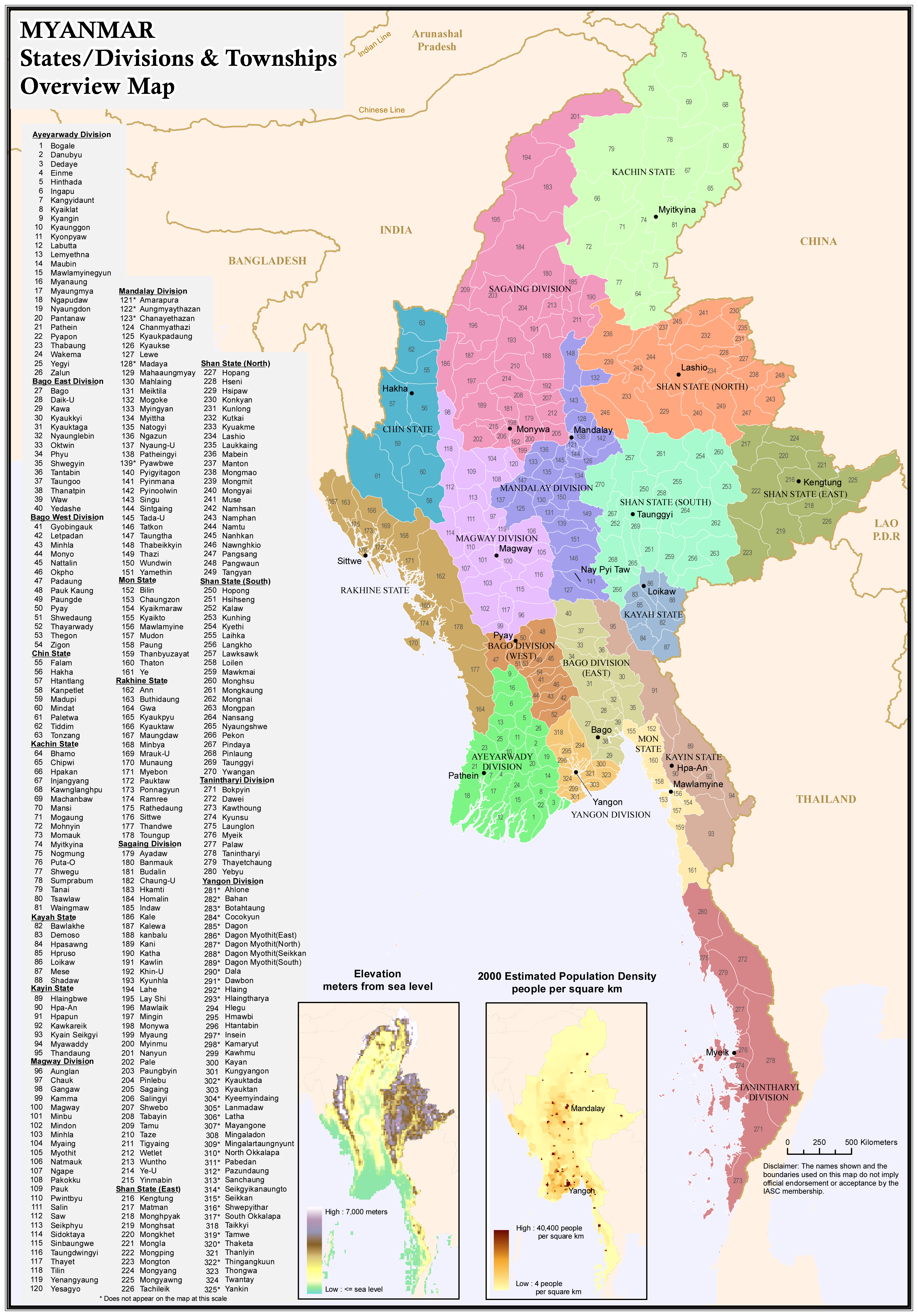
Myanmar is situated on the west of the Southeast Asian peninsula, bordering India on the northwest and China on the northeast. Bangladesh lies to the west and Thailand and Laos to the east. The country has a 1,770-mile coastline that faces west and borders the Bay of Bangal and the Andaman Sea. Myanmar is roughly the size of the state of Texas, and larger than any European country, excluding Russia, with an area of 261,228 square miles (678,500 sq. km). It is also largest country in mainland Southeast Asia. The shape resembles that of kite, with a long tail drifting down the peninsula toward Malaysia.
Myanmar’s most prominent geographical feature is the 1,350 mile Irrawaddy River, flowing north to south. Other important rivers nourishing this rice-growing land are the Salween and the Chindwin. The rivers serve as Myanmar RTERIES, WHILE THE MOUNTAIN RANGES OF East Yoma, Bagao Yoma and West Yoma stand like sentries on guard duty. Myanmar’s highest peak, Hkakabo Razi in Kachin State, reaches 19,295 feet. Snow-capped mountain ranges mark Myanmar’s northernmost frontier with China.
The Shan plateau has its famous natural attraction, Inle Lake, situated 2,900 feet above the sea level. A freshwater lake, where the inhabitants lives in stilted homes surrounded by floating island, Inle Lake in nearly fourteen miles long and more than six miles across at its widest point. A unique feature of the lake is the way the people who live on its shores, the Inthas, use their legs to paddle their boats.
Climate
Myanmar stretches from the sparsely populated mountain north, where it border China, to the tropical south, and there are huge variations in climate. In the extreme north winters can be bitterly cold, but the inhabited parts of the country never experience extreme cold.
There are three seasons a year. Most of the country lies within the tropics and enjoys a hot season from March to mid-May, with temperatures reaching 35C. The rainy season begins from the third week of May, when monsoon rains envelop the country. The rains are heaviest during July and August, and taper off in October. The cool months are from November to February. While temperatures at this time dip below the freezing point in the north, For Yangon and other big cities in the central Myanmar it is pleasantly warm, around 68-77C.


